Omitted interiors#
import geopandas
import numpy
import matplotlib.pyplot as plt
import geoplanar
from shapely.geometry import box, Point
For a planar enforced polygon layer there should be no individual polygons that are contained inside other polygons.
Violation of this condition can lead to a number of errors in subsequent spatial analysis.
Violation: Points within more than a single feature#
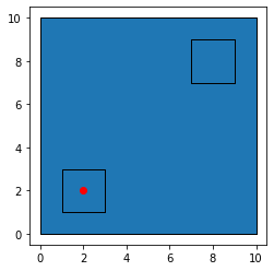
If this were not the case, then it would be possible for a point to be contained inside more than a single polygon which would be a violation of planar enforcement. An example can be seen as follows:
p1 = box(0,0,10,10)
p2 = box(1,1, 3,3)
p3 = box(7,7, 9,9)

gdf = geopandas.GeoDataFrame(geometry=[p1,p2,p3])
base = gdf.plot(edgecolor='k')

pnt1 = geopandas.GeoDataFrame(geometry=[Point(2,2)])
pnt1.plot(ax=base,color='red')
<AxesSubplot:>
pnt1.within(gdf.geometry[0])
0    True
dtype: bool
pnt1.within(gdf.geometry[1])
0    True
dtype: bool
The violation here is that pnt1 is within both polygon p1 and p2.
Error in area calculations#
A related error that arises in this case is that the area of the “containing” polygon will be too large, since it includes the area of the smaller polygons:
gdf.geometry[0]

gdf.area
0    100.0
1      4.0
2      4.0
dtype: float64
gdf.area.sum()
108.0
Missing interior rings (aka holes)#
The crux of the issue is that the two smaller polygons are entities in their own right, yet the large polygon was defined to have only a single external ring. It is missing two interior rings which would allow for the correct topological relationship between the larger polygon and the two smaller polygons.
geoplanar can detect missing interiors:
mi = geoplanar.missing_interiors(gdf)
mi
[(0, 1), (0, 2)]
Adding interior rings#
Once we know that the problem is missing interior rings, we can correct this with add_interiors:
gdf1 = geoplanar.add_interiors(gdf)
gdf1.geometry[0]

And we see that the resulting area of the GeoSeries is now correct:
gdf1.area
0    92.0
1     4.0
2     4.0
dtype: float64
Additionally, a check for missing_interiors reveals the violation has been corrected
geoplanar.missing_interiors(gdf1)
[]
The addition of the interior rings also corrects the violation of the containment rule that a point should belong to at most a single polygon in a planar enforced polygon GeoSeries:
pnt1.within(gdf1.geometry[0])
0    False
dtype: bool
pnt1.within(gdf1.geometry[1])
0    True
dtype: bool
Failure to detect contiguity#
A final implication of missing interiors in a non-planar enforced polygon GeoSeries is that algorithms that rely on planar enforcement to detect contiguous polygons will fail.
More specifically, in pysal, fast polygon detectors can be used to generate so called Queen neighbors, which are pairs of polygons that share at least one vertex on their exterior/interior rings.
import libpysal
w = libpysal.weights.Queen.from_dataframe(gdf)
/home/serge/Documents/p/pysal/src/subpackages/libpysal/libpysal/weights/weights.py:172: UserWarning: The weights matrix is not fully connected:
 There are 3 disconnected components.
 There are 3 islands with ids: 0, 1, 2.
  warnings.warn(message)
w.neighbors
{0: [], 1: [], 2: []}
The original GeoDataFrame results in fully disconnected polygons, or islands. pysal at least throws a warning when islands are detected, and for this particular type of planar enforcement violation, missing interiors, the contained polygons will always be reported as islands.
Using the corrected GeoDataFrame with the inserted interior rings results in the correct neighbor determinations:
w = libpysal.weights.Queen.from_dataframe(gdf1)
w.neighbors
{0: [1, 2], 1: [0], 2: [0]}